"Geospatial Portal" mainly integrates the various geographic information system websites of the Cartography and Cadastre Bureau to build a query platform, so that the public can directly find the required geospatial information simply and quickly. Through the portal, users can search by keyword or by categorized item, and then enter the geographic information system or government agency websites by clicking on the search results to access the detailed information. 
https://www.gis.gov.mo/geoportal/Last revision date: 2015/12
"Macao Online Map", an e-map combining Geographic Information System (GIS) and the internet, mainly provides geographic information such as parish, water, hill, greenbelt, bridge and tunnel, street, construction, door number etc. Geographic information on construction, street, scenic spot etc., can be searched or browsed by inputting keywords or using map browsing tools (zoom in, zoom out and pan etc.) through internet to offer Macao updated map information.
https://webmap.gis.gov.mo/The base map data was last updated on: 2023/09
The mobile version of the “Macao 3D Map” is created on the basis of the three-dimensional map of Macao, combined with the technology advantages of the mobile device, multi-touch technology and the cloud application, which simplify the operations of 3D map in conjunction with delicate and detailed 3D models of all buildings in Macao. The public can browse the scenes of 3D map conveniently through their mobile phones or tablet devices. The system provides search function for the building's name, and includes preset specific scenes to choose from, allowing citizens and tourists to view the three-dimensional city landscape of Macao.
https://map3d.gis.gov.mo/3D map data last updated on: 2021/08
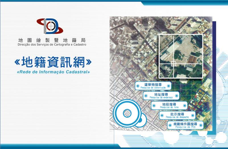
"Cadastral Information Website" is a comprehensive land information platform that integrates information on land and buildings in all departments. Users can search for land concession information, easement and encumbrances, buildings, lots, cartographic servitude right, the urban conditional plans (PCU), data on the highest altitude allowed for the construction of buildings in areas surrounding Farol da Guia, the description number of property registration , slope classification and maintenance responsibility, the list of historical cities and cultural relics for protection, administrative division boundaries, and other relevant applicable regulations. Additionally, the website also contains land-related statistics, administrative procedures and legislation to provide citizens with a wide range of information.
With the popularization of smartphones and mobile data applications, more users use smartphones as their main internet-surfing tool. In order to facilitate access to land information for mobile internet users, the Cartography and Cadastre Bureau launched the mobile version of "Cadastral Information Website" in 2018, providing the public with a service platform suitable for browsing operations on smartphones or tablets (iOS and Android).

https://cadastre.gis.gov.mo/
The base map data was last updated on: 2023/09
"Macau GeoGuide" is a mobile map application published by the Cartography and Cadastre Bureau, provides a full range of geographic information services for citizens and tourists. It uses professional mapping technology, combined with the advantages of mobile platform and multi-touch, so that users can obtain the latest geographic information anytime and anywhere, bringing brand new use experience to the users. When using outdoor, users can easily locate the necessary geographic information around, such as health care, food, housing, transportation, education and entertainment, and use the point to point route planning function to find an appropriate travel route.
https://www.dscc.gov.mo/geoguide/ios_android/default_eng.html
The base map data was last updated on: 2023/09
In order to let the public obtain more geographic information for emergency via mobile phone, Cartography and Cadastre Bureau, under the support of Unitary Police Service, Meteorological and Geophysics Bureau, Environmental Protection Bureau, Marine and Water Bureau, Municipal Affairs Bureau, Education and Youth  Development Bureau and Social Welfare Bureau, has launched the“GeoGuide for emergency” mobile map App. In addition to providing important information such as the areas may be affected during different “Storm Surge” warning levels, zones may be affected by Power Suspension Measures, real-time water level monitoring information, real-time severe weather warnings information and location of each Emergency Refuge Centre, the App also includes the function of walking route planning to the nearest Emergency Refuge Centre in advance.
 
https://www.dscc.gov.mo/geoguide/emergency/

The base map data was last updated on: 2023/09

 
"Traffic Geographic Information Website" displays every roadworks on Macao map by using the technology of the geographic information system in order to show Macao traffic condition visually to public. Moreover, this system would be a good helper to citizens for understanding the latest road condition, as the information in this system will be updated everyday and new functions will be issued gradually.

https://traffic.gis.gov.mo
The base map data was last updated on: 2023/09
"Macao Satellite Positioning Reference Station Service" provides users with satellite observation data downloading service of the four satellite positioning reference stations in Macao as well as coordinate calculation service. Through the website, registered users can access the data quality reports of the Fortaleza do Monte GNSS Reference Station (FOMO), the Taipa Grande GNSS Reference Station (DSMG), the Coloane Alto GNSS Reference Station (COAL) and University of Macau GNSS Reference Station (UMAC) for the past 30 days, check the availability of data, and download the required raw data of the reference stations for the past three months. The website also provides an automatic coordinate calculation service. Users only need to upload the collected satellite observation data to obtain the coordinate results through the system.
Moreover, under the "Data Sharing between Macao and Hong Kong  Satellite Positioning Reference Stations" between the Cartography and Cadastre Bureau of the Government of the Macao Special Administrative Region and the Lands Department of the Government of the Hong Kong Special Administrative Region, users can also download satellite observation data of four satellite positioning reference stations in Hong Kong, namely: Lam Tei Station (HKLT), Siu Lang Shui Station (HKSL), Mui Wo Station (HKMW) and Ngong Ping Station (HKNP).
https://mosref.dscc.gov.mo/
Satellite Positioning Reference Station-observed Data Last Updated: Updated every fifteen minutes
Address information is closely related to the daily life of citizens. To facilitate citizens' access to relevant information, the Cartography and Cadastre Bureau has developed the "Macao Street and Door Number Enquiry System " on the basis of the online map to provide street and door-number enquiry service through a simple operation interface; its scope of application includes queries about traditional Chinese and Portuguese names of streets and buildings, queries about streets where specific buildings are located and the first and last door numbers , searches for corresponding buildings by streets and door numbers , and display of location maps of streets and buildings.
https://webmap.gis.gov.mo/AddressSearch/
The base map data was last updated on: 2023/09
In response to the continuous improvement of various walking systems and facilities in Macao, the Cartography and Cadastre Bureau has cooperated with the Transport Bureau, the Land and Urban Construction Bureau (formerly the Land, Public Works and Transport Bureau), the Municipal Affairs Bureau and the Cultural Affairs Bureau to launch the Walking Routes Map and a thematic website. It mainly provides cross-district walking system and facility information, so that the citizens can walk to various districts in a safe, comfortable, convenient and time-saving way.
Furthermore, the thematic website also integrates the walking routes of “Taking a Walk through the Streets of Macao – Knowing about Macao” launched by the Municipal Affairs Bureau and the “Macao Cultural and Creative Map” launched by the Cultural Affairs Bureau. Users can learn about the content of each walking route through the thematic website and view the scenic spots along the routes through 360 panoramic photos. Using a mobile device to browse the “Walking Route Map” can also obtain the real-time location information, which facilitate the travel of citizens and tourists.

https://routemap.dscc.gov.mo/
Last revision date: 2022/03
The “Applications Programming Interface for Geographic Information” provides a gateway to all Macao map services, allowing the public and private companies to view the latest Macao map via the website or mobile application (APP).

https://www.dscc.gov.mo/mapapi/
 

Cartography and Cadastre Bureau

Telephone: (853)2834 0040
Fax: (853)2834 0046
E-mail: mail@dscc.gov.mo
P.O. Box: Macao P.O. Box 3018
Office hours:  Monday to Thursday 9:00-13:00 and 14:30-17:45
Friday 9:00-13:00 and 14:30-17:30
Address: Estrada de D. Maria II, 32-36, Edificio CEM, 5th floor, Macao
QR code: 
Last Updated:

[Usage Disclaimer] [Privacy Statement] [Sitemap]
Copyright©Cartography and Cadastre Bureau