-
 Home
Home
-
 About Us

-
 Service Application

-
 Latest News
-
 Statistics
-
 Geographical Knowledge

-
 Geographic Information Application

-
 Introduction
-
 Geospatial Portal
-
 Macao Online Map
-
 Macao 3D Map
-
 Cadastral Information Website
-
 Macau GeoGuide
-
 GeoGuide for emergency
-
 Traffic Geographic Information Website
-
 Macao Satellite Positioning Reference Station Service (MoSRef) Website
-
 Macao Street and Door Number Enquiry System
-
 Walking Routes Map
-
 Applications Programming Interface for Geographic Information
-
-
 Tender

-
 Opinions
-
 Contact Us

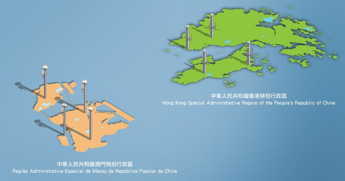
The distribution of the Sharing reference stations of Macao and Hong Kong
Basic information on the satellite positioning reference stations of Hong Kong:
|
HKSL |
HKNP |
HKLT |
HKMW |
|
|---|---|---|---|---|
|
Year of establishment |
2000 |
2004 |
2000 |
2004 |
|
Location |
Siu Lang Shui, Tuen Mun |
Ngong Ping, Lantau Island |
Lam Tei, Tuen Mun |
Mui Wo, Lantau Island |
|
Type of receiving satellite |
GPS、GLONASS and BeiDou |
GPS、GLONASS and BeiDou |
GPS、GLONASS and BeiDou |
GPS、GLONASS and BeiDou |
|
Receiver model |
Leica GR50 |
Leica GR50 |
Leica GR50 |
Trimble NETR9 |
|
Antenna model |
Leica AR25 R4 |
Leica AR25 R4 |
Leica AR25 R4 |
Leica AR25 R4 |
|
Data format |
RINEX v3.02 |
RINEX v3.02 |
RINEX v3.02 |
RINEX v3.02 |
|
Coordinate system |
ITRF2005 |
ITRF2005 |
ITRF2005 |
ITRF2005 |
|
Photo album |
Description of data sharing of satellite positioning reference stations of Hong Kong:
- Observation data of Hong Kong reference stations are provided by the Lands Department of Hong Kong in the format of RINEX v3.02. The coordinates in the header of the RINEX file downloaded are based on the coordinate system of Macao(the ITRF2005 framework). For the ITRF2005 coordinates for Hong Kong reference stations, please refer to the relevant information on MoSRef website.
- The "coordinate calculation service" provided by MoSRef does not use the observation data of Hong Kong reference stations.
- The real-time network RTK correction message sent by the Macao Cartography and Cadastre Bureau includes the real-time data from Hong Kong reference stations.
Cartography and Cadastre Bureau
Friday 9:00-13:00 and 14:30-17:30
[Usage Disclaimer] [Privacy Statement] [Sitemap]
Copyright©Cartography and Cadastre Bureau
