-
 Home
Home
-
 About Us

-
 Service Application

-
 Latest News
-
 Statistics
-
 Geographical Knowledge

-
 Geographic Information Application

-
 Introduction
-
 Geospatial Portal
-
 Macao Online Map
-
 Macao 3D Map
-
 Cadastral Information Website
-
 Macau GeoGuide
-
 GeoGuide for emergency
-
 Traffic Geographic Information Website
-
 Macao Satellite Positioning Reference Station Service (MoSRef) Website
-
 Macao Street and Door Number Enquiry System
-
 Walking Routes Map
-
 Applications Programming Interface for Geographic Information
-
-
 Tender

-
 Opinions
-
 Contact Us
The Cartography and Cadastre Bureau (DSCC) has cooperated with the Transport Bureau, the Land and Urban Construction Bureau, the Municipal Affairs Bureau and the Cultural Affairs Bureau to establish the “Walking Routes Map” and the thematic website, providing a convenient way for the citizens to learn about the latest walking systems and facilities in Macao and to meet the needs of the citizens. In response to the continuous improvement of various walking systems and facilities in Macao and the pedestrian tunnel of Guia Hill is opened. The DSCC launched the updated version of the “Walking Routes Map” and the respective thematic website.
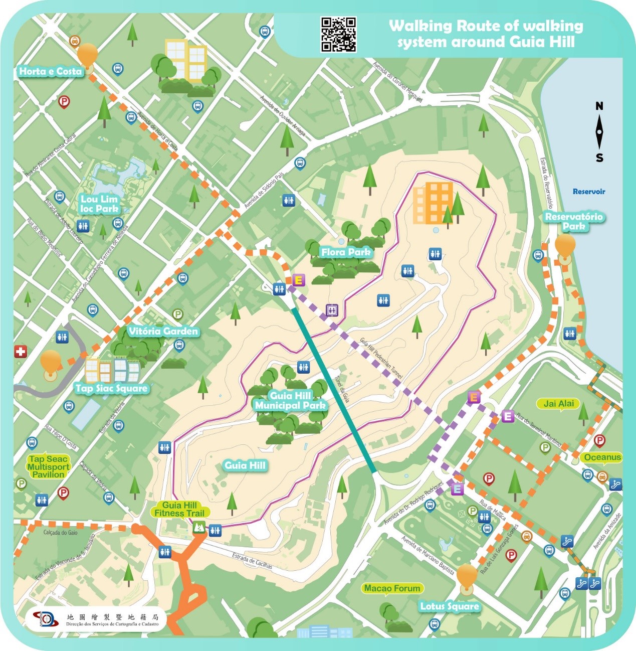
In this updated version, the “Walking Route of walking system around Guia Hill” was added, introducing the walking route and the required walking time between the pedestrian tunnel of Guia Hill, Reservatório Park, Lotus Square, Avenida de Horta e Costa and Tap Seac Square; In the same time, the “Walking Routes Map” also provides location information of various cross-district walking systems, pedestrian crossing facilities, car parks, bus stops and taxi stops, so that the citizens can walk to various districts in a safe, comfortable, convenient and time-saving way.
The citizens can browse the thematic website through computer or mobile device to learn about the above-mentioned walking route information and view the scenic spots along the routes through 360 panoramic photos. Using a mobile device to browse the “Walking Route Map” can also obtain the function of real-time location information, encouraging citizens to take ecological tours through geographic information technology. Citizens are welcome to visit the thematic website of walking routes by scanning the QR code below or entering the website address (https://routemap.dscc.gov.mo/).
 |
|
The thematic website of walking routes QR CODE
|
 |
|
Walking Route of walking system around Guia Hill
|
Cartography and Cadastre Bureau
Friday 9:00-13:00 and 14:30-17:30
[Usage Disclaimer] [Privacy Statement] [Sitemap]
Copyright©Cartography and Cadastre Bureau
