-
 Home
Home
-
 About Us

-
 Service Application

-
 Latest News
-
 Statistics
-
 Geographical Knowledge

-
 Geographic Information Application

-
 Introduction
-
 Geospatial Portal
-
 Macao Online Map
-
 Macao 3D Map
-
 Cadastral Information Website
-
 Macau GeoGuide
-
 GeoGuide for emergency
-
 Traffic Geographic Information Website
-
 Macao Satellite Positioning Reference Station Service (MoSRef) Website
-
 Macao Street and Door Number Enquiry System
-
 Walking Routes Map
-
 Applications Programming Interface for Geographic Information
-
-
 Tender

-
 Opinions
-
 Contact Us
Macao SAR Coastline
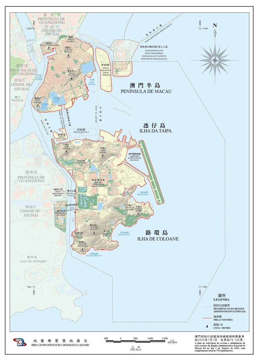
To facilitate effective administration of the water area and support the implementation of the Maritime Areas Management Framework Law, the Macao SAR government promulgated through The Dispatch of the Chief Executive No. 209/2025, the Coastline Map of Macao Special Administrative Region, which revises the demarcated coastline of the territory. By delineating the location of the coastline of the Macao Special Administrative Region, it offers geographic information that is crucial to the management of land and the water area in Macao.
This publication of the Macao Special Administrative Region coastline is based on the reference survey date on May 1, 2025, measured 79.5 km. Including 18.5 km of the Macao Peninsula, 49.5 km of the outlying islands (including Taipa Island, Cotai Reclaimed Area, and Coloane Island), 5.7 km of the New Urban Zone A, 2.7 km of the Macao Port Administration Area at the Zhuhai-Macao Port Artificial Island of the Hong Kong-Zhuhai-Macao Bridge, and 3.1 km of the New Urban Zone C.
《Coastline Map of Macao SAR》
This publication of the Macao Special Administrative Region coastline is based on the reference survey date on May 1, 2025, measured 79.5 km. Including 18.5 km of the Macao Peninsula, 49.5 km of the outlying islands (including Taipa Island, Cotai Reclaimed Area, and Coloane Island), 5.7 km of the New Urban Zone A, 2.7 km of the Macao Port Administration Area at the Zhuhai-Macao Port Artificial Island of the Hong Kong-Zhuhai-Macao Bridge, and 3.1 km of the New Urban Zone C.
Statistics of the Regional Coastline Lengths of Macao SAR
| Coastline Length (Kilometer) |
Scale(%) | |
|---|---|---|
| Macao Peninsula | 18.5 | 23.3 |
| Outlying Islands (including Taipa Island, Cotai Reclaimed Area, and Coloane Island) |
49.5 | 62.2 |
| New Urban Zone A | 5.7 | 7.2 |
| Zhuhai-Macao Port Artificial Island of the Hong Kong-Zhuhai-Macao Bridge Macao Port Administration Area |
2.7 | 3.4 |
| New Urban Zone C | 3.1 | 3.9 |
| Total | 79.5 | 100 |
Cartography and Cadastre Bureau
Office hours: Monday to Thursday 9:00-13:00 and 14:30-17:45
Friday 9:00-13:00 and 14:30-17:30
Friday 9:00-13:00 and 14:30-17:30
Address: Estrada de D. Maria II, 32-36, Edificio CEM, 5th floor, Macao
QR code:


Last Updated:
[Usage Disclaimer] [Privacy Statement] [Sitemap]
Copyright©Cartography and Cadastre Bureau

