-
 Home
Home
-
 About Us

-
 Service Application

-
 Latest News
-
 Statistics
-
 Geographical Knowledge

-
 Geographic Information Application

-
 Introduction
-
 Geospatial Portal
-
 Macao Online Map
-
 Macao 3D Map
-
 Cadastral Information Website
-
 Macau GeoGuide
-
 GeoGuide for emergency
-
 Traffic Geographic Information Website
-
 Macao Satellite Positioning Reference Station Service (MoSRef) Website
-
 Macao Street and Door Number Enquiry System
-
 Walking Routes Map
-
 Applications Programming Interface for Geographic Information
-
-
 Tender

-
 Opinions
-
 Contact Us

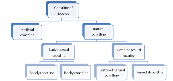
Distribution of types of Macao SAR coastlines
| Types of coastlines |
Total length |
Scale |
Macau Peninsula |
Macao Peninsula |
New urban zone A(Kilometer) |
Artificial Island of the Hong Kong-Zhuhai-Macao Bridge |
New urban zone C(Kilometer) |
|---|---|---|---|---|---|---|---|
|
Artificial coastline |
67.0 |
84.3 |
18.4 |
37.1 |
5.7 |
2.7 |
3.1 |
|
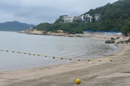
Sandy coastline |
2.2 |
2.8 |
0.1 |
2.1 |
0.0 |
0.0 |
0.0 |
|
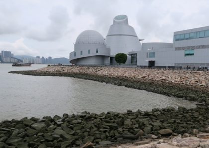
Rocky coastline |
5.2 |
6.5 |
0.0 |
5.2 |
0.0 |
0.0 |
0.0 |
|
Spontaneously recuperated |
0.0 |
0.0 |
0.0 |
0.0 |
0.0 |
0.0 |
0.0 |
|
Renovated coastline |
5.1 |
6.4 |
0.0 |
5.1 |
0.0 |
0.0 |
0.0 |
* Outlying Islands (including Taipa Island, Cotai Reclaimed Area, and Coloane Island)
|
Artificial Slope Embankment Coastline |
Artificial Vertical Embankment Coastline |
|
Sandy Coastline |
Rocky Coastline |
|
Renovated Coastline |
|
Utilization status of Macao SAR coastlines
The coastlines are classified according to their development and utilization status. The types of coastlines developed and utilized by Macao SAR mainly include industrial coastline, transportation coastline, tourism coastline, urban and rural construction coastline and other coastlines, accounting for 92.6% of the total coastline length. In addition, the unutilized coastline is mainly composed of rocky coastline and sandy coastline that do not have the function of sightseeing and tourism. They are mainly distributed in the south of Coloane Island and the north of Taipa Island, accounting for 7.4% of the total coastline length.
Distribution of the Utilization Status of Macao SAR Coastlines
Types of utilization |
Total length |
Scale |
Macau Peninsula |
Outlying Islands* |
New urban zone A(Kilometer) |
Macao Port Administration Area of Zhuhai-Macao Port Artificial Island of the Hong Kong-Zhuhai-Macao Bridge(Kilometer) |
New urban zone C(Kilometer) |
|---|---|---|---|---|---|---|---|
|
Industrial coastline |
2.7 |
3.4 |
0.0 |
2.7 |
0.0 |
0.0 |
0.0 |
|
Transportation coastline |
20.3 |
26.9 |
3.6 |
16.7 |
0.0 |
0.0 |
0.0 |
|
Tourism coastline |
13.7 |
17.2 |
4.0 |
9.7 |
0.0 |
0.0 |
0.0 |
|
Urban and rural construction coastline |
33.8 |
42.6 |
10.2 |
12.1 |
5.7 |
2.7 |
3.1 |
|
Other coastlines |
3.1 |
3.9 |
0.0 |
3.1 |
0.0 |
0.0 |
0.0 |
|
Unutilized coastlines |
5.9 |
7.4 |
0.7 |
5.2 |
0.0 |
0.0 |
0.0 |
* Outlying Islands (including Taipa Island, Cotai Reclaimed Area, and Coloane Island)
Cartography and Cadastre Bureau
Friday 9:00-13:00 and 14:30-17:30
[Usage Disclaimer] [Privacy Statement] [Sitemap]
Copyright©Cartography and Cadastre Bureau


